


Voting District 50405, Placer County, California
About
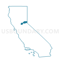
Outline

Summary
| Unique Area Identifier | 536676 |
| Name | Voting District 50405 |
| County | Placer County |
| State | California |
| Area (square miles) | 15.58 |
| Land Area (square miles) | 15.48 |
| Water Area (square miles) | 0.09 |
| % of Land Area | 99.40 |
| % of Water Area | 0.60 |
| Latitude of the Internal Point | 39.11177140 |
| Longtitude of the Internal Point | -120.94388560 |
Maps


Graphs
Select a template below for downloading or customizing gragh for Voting District 50405, Placer County, California


Neighbors
Neighoring Voting District (by Name) Neighboring Voting District on the Map
- Voting District 10005, Nevada County, CA
- Voting District 20085, Nevada County, CA
- Voting District 20090, Nevada County, CA
- Voting District 50090, Placer County, CA
- Voting District 50095, Placer County, CA
- Voting District 50105, Placer County, CA
- Voting District 50110, Placer County, CA
- Voting District 50315, Nevada County, CA
- Voting District 50400, Placer County, CA
- Voting District 50410, Placer County, CA
- Voting District 50415, Placer County, CA
- Voting District 50420, Placer County, CA
- Voting District 50425, Placer County, CA
- Voting District 50445, Placer County, CA
Top 10 Neighboring County Subdivision (by Population) Neighboring County Subdivision on the Map
- Grass Valley CCD, Nevada County, CA (66,614)
- Colfax-Monumental Ridge CCD, Placer County, CA (20,351)
- Foresthill-Back Country CCD, Placer County, CA (6,146)
Top 10 Neighboring Place (by Population) Neighboring Place on the Map
Top 10 Neighboring Elementary School District (by Population) Neighboring Elementary School District on the Map
- Pleasant Ridge Union Elementary School District, CA (20,577)
- Nevada City Elementary School District, CA (15,411)
- Placer Hills Union Elementary School District, CA (13,646)
- Colfax Elementary School District, CA (5,304)
- Alta-Dutch Flat Union Elementary School District, CA (1,787)
- Chicago Park Elementary School District, CA (1,204)
Top 10 Neighboring Secondary School District (by Population) Neighboring Secondary School District on the Map
Top 10 Neighboring State Legislative District Lower Chamber (by Population) Neighboring State Legislative District Lower Chamber on the Map
Top 10 Neighboring State Legislative District Upper Chamber (by Population) Neighboring State Legislative District Upper Chamber on the Map
Top 10 Neighboring 111th Congressional District (by Population) Neighboring 111th Congressional District on the Map
Top 10 Neighboring Census Tract (by Population) Neighboring Census Tract on the Map
- Census Tract 1.03, Nevada County, CA (7,893)
- Census Tract 7.01, Nevada County, CA (7,436)
- Census Tract 220.02, Placer County, CA (6,481)
- Census Tract 202, Placer County, CA (6,146)
- Census Tract 7.02, Nevada County, CA (3,968)
- Census Tract 220.13, Placer County, CA (2,934)